 The River Burn is a chalk stream 12 km long, has a catchment of 100 sq. km and falls just 36 m from source to sea. A barely noticeable presence, it signifies itself through the settlements of Burnham Norton, Burnham Deepdale, Burnham Overy Town, Burnham Overy Staithe, Burnham Market (Burnham up-Market, surely) and Burnham Thorpe (Nelson’s birthplace).
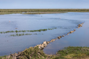
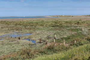 In medieval times the estuary of the Burn was a harbour, Skottermouth, protected from northerly gales by the dunes of the Burnham Meals. It was an important hub for waterborne trade. Shallow-draft dinghies now edge slowly along the remaining channels towards the gap between Scolt Head and Gun Hill, still called Burnham Harbour. Traces of earlier structures, earlier functions, decay slowly into the Overy saltmarsh.
Photos: Burnham Overy Staithe, Norfolk, July 2017